Plate Tectonics Worksheets


About Our Plate Tectonics Reading Worksheets
Plate tectonics is basically Earth's way of keeping things interesting-giant slabs of crust gliding, colliding, and sliding around on the squishy upper mantle. These motions are slow, but the results are spectacular: mountains rise, volcanoes erupt, oceans open, and continents drift like very patient rafts. It's the engine room of geology, quietly shaping the map while we go about our day.
Why does it matter? Plate tectonics explains earthquakes in California, volcanoes in the Pacific Ring of Fire, and the Himalayas punching skyward. It drives the rock cycle, recycles crust, and even influences climate over millions of years. Without it, Earth would be a geologically boring, static rock-and probably less hospitable to life.
Our Plate Tectonics worksheets turn the slow-motion drama beneath our feet into a classroom adventure. Using diagrams, cross-sections, and problem-solving questions, students explore how plates move and interact. Each PDF comes with an answer key, so teachers can focus on sparking curiosity instead of second-guessing answers.
A Look At Each Worksheet
Plate Boundaries
Divergent, convergent, and transform-this worksheet breaks down the three main types of boundaries. Students match diagrams to real-world examples like the Mid-Atlantic Ridge and the San Andreas Fault. By the end, they can read a tectonic map like a travel guide.
Seafloor Spreading
From mid-ocean ridges to magnetic striping, this worksheet dives into how new oceanic crust forms. Students connect seafloor data with the theory that confirmed plate tectonics. It's geology with a side of detective work.
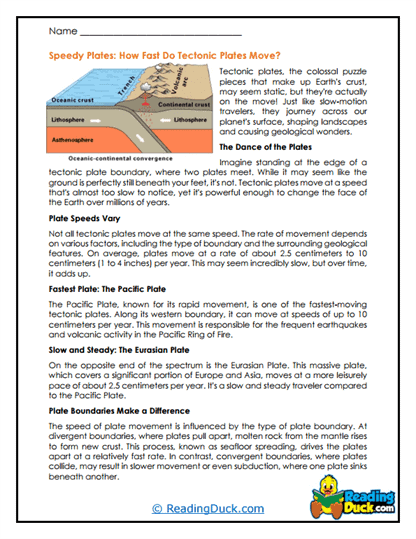
Subduction Zones
When one plate dives under another, you get trenches, volcanoes, and earthquakes. This worksheet explores the anatomy of subduction zones and their global significance. Students see why these zones are both destructive and creative.
Hot Spots
Hawaiian islands, Yellowstone-these aren't just pretty landscapes, they're proof of mantle plumes. This worksheet explains hot spot volcanism and how it can occur far from plate boundaries. Learners map island chains to see plume paths over time.
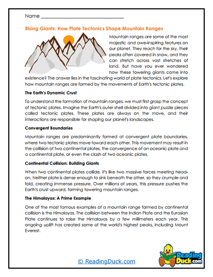
Mountain Building
Colliding plates don't just crash-they crumple. This worksheet details how fold mountains like the Andes and Himalayas form. Students connect plate motions to the topography they can see from space.
Transform Faults
Side-by-side sliding might sound polite, but it's where earthquakes thrive. This worksheet uses diagrams to show motion, stress, and seismic effects at transform boundaries. It's a horizontal take on tectonic hazards.
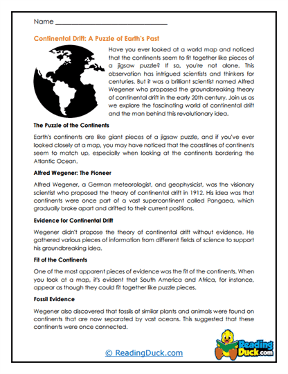
Continental Drift History
Before plate tectonics, there was Alfred Wegener's bold idea that continents move. This worksheet covers his evidence, from fossil matches to rock formations across oceans. It's the origin story of modern geology.
Earthquake Connections
Where plates grind, quakes follow. This worksheet links plate boundaries to seismic activity, using maps and real earthquake data. Students learn to predict where tremors are most likely.
Volcano Connections
Not all volcanoes are equal-some are boundary-born, others from hot spots. This worksheet categorizes volcano types and ties them to tectonic settings. Expect some explosive "aha" moments.
Tectonic Maps
Reading a tectonic map is a skill in itself. This worksheet gives students practice identifying plate names, boundaries, and motion directions. They'll leave with cartographic confidence.
Rift Valleys
When plates pull apart on land, you get dramatic sunken valleys. This worksheet explains their formation, with the East African Rift as the star example. It's continental breakup in action.
Plate Motion Evidence
From GPS data to paleomagnetism, this worksheet reviews the proof that plates are on the move. Students weigh different evidence types and see how science builds a case. The takeaway? The ground beneath us is never truly still.
About Plate Tectonics
Plate tectonics is the unifying theory of geology, describing how Earth's lithosphere is broken into plates that move over the asthenosphere. The plates are driven by mantle convection, slab pull, and ridge push-a mix of forces that keep continents and ocean floors in constant motion. This movement rearranges geography, recycles crust, and powers some of the most dramatic natural events on the planet.
The idea evolved from Alfred Wegener's early 20th-century theory of continental drift. While Wegener had good evidence, he lacked a mechanism. That came in the mid-20th century with the discovery of mid-ocean ridges, magnetic striping, and symmetrical patterns of seafloor spreading. These findings, along with earthquake and volcano distribution maps, solidified plate tectonics as a cornerstone of Earth science.
Recent research uses GPS to measure plate movements down to millimeters per year. Seismic tomography now images subducted slabs sinking into the mantle, and deep-sea drilling recovers samples from critical boundaries. These tools have confirmed complex interactions, like microplates and triple junctions, adding nuance to the theory.
Plate tectonics shapes life on Earth in profound ways. It creates mountains that influence weather, opens ocean basins that redirect currents, and recycles carbon between the surface and deep Earth. Without it, Earth's surface would be much more static-and likely less hospitable.
The future of plate tectonics research includes better modeling of mantle convection, improved earthquake forecasting at plate boundaries, and understanding how tectonics started early in Earth's history. Big questions remain: When did plate tectonics truly begin? Will it ever stop? And what would Earth look like if the plates one day locked into place?